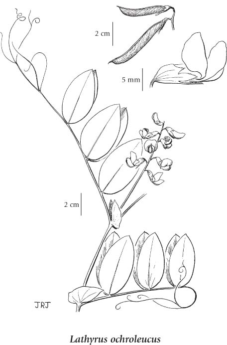
General: Perennial herb from a creeping rhizome; stems erect to clambering, 30-100 cm tall/long, inconspicuously angled, not winged, glabrous.
Leaves: Alternate, pinnately compound with 6 to 8 leaflets in pairs; leaflets narrowly egg-shaped to elliptic, 3-7 cm long, 1-4 cm wide; tendrils well developed, usually branched and grasping; stipules 1/3-2/3 the length of the leaflets, narrowly egg-shaped, not lobed.
Flowers: Inflorescence a loose, stalked, axillary cluster of 6 to 14 pea-like flowers; corollas creamy-yellow to greenish-white, 12-17 mm long, the banner 14-17 mm long, the banner-claw shorter than the blade, the wings the same size as the keel and shorter than the banner; calyces 8-10 mm long, glabrous except for a fringe of hairs on the teeth, the upper pair of teeth about 1/2 as long as the lower.
Fruits: Pods, 4-7 cm long, 4-7 mm wide, hairless, brown with age; seeds 5 to 12.
Mesic to moist, open forests, thickets, glades, meadows and rocky ridges in the montane zone; common in BC east of the Coast-Cascade Mountains and south of 57oN, infrequent northwards; N to NT, E to PQ and S to OH, PA, VT, SD, WY and NE WA.
The table below shows the species-specific information calculated from original data (BEC database) provided by the BC Ministry of Forests and Range. (Updated August, 2013)
A shade-tolerant/intolerant, montane, North American forb distributed in the Cordilleran and Central regions. Occurs in continental boreal and wet cool temperate climates on moderately dry to fresh, nitrogen-rich soils in the coast-interior ecotone; its occurrence increases with increasing continentality and latitude, and decreases with increasing elevation. Common in semi-open forests on baserich, water-shedding and water-receiving sites. Symbiotic relationship with nitrogen-fixing bacteria enhances the supply of available soil nitrogen. Characteristic of Moder and Mull humus forms.